|
Project
Areas
The project areas are known
as “Hill District” of Bangladesh located on
the south-eastern part of the country. The
project activities will be limited to the
municipality areas. Following is a brief on
the targeted municipalities.
Rangamati
Rangamati Municipality (Paurashava)
is located at the district head quarter of
Rangamati Hill District. Earlier, it was the
headquarter of Chittagong Hill Tracts. The
district is located approximately 21030¢
to 2390¢ north latitude and 91055¢
to 92040¢east longitude. The
district is surrounded by Tripura, India in
North; Bandarban district and Myanmar in
South; Mijoram, India in East; Khagrachari
district and Chittagong district in West.
Rangamati Paurashava is located at the
central part of the district approximately
within 22030¢ to 22090¢
north latitude and 91055¢ to 92040¢east
longitude. The whole town is on the Hill top
and surrounded by Kaptai Lake in three
sides.

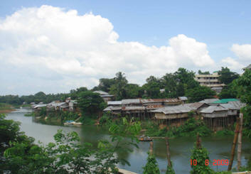
Typical
Lakeside development in Rangamati
Municipality
Rangamati Paurashava is the
only urban area of Rangamati Sadar Upazila,
consists nine wards and 36 mahallah.
Rangamati comprises an area of 64.75 sq. km
(including part of Kaptai Lake, hilly forest
area). According to population Census 2001
the total population of the Paurashava is
66836. Total household of the municipality
is 13620 (BBS Report, 2005). The town is
developing bit haphazardly mostly cutting
hill sides which is a threat to the newly
developed settlements with possible
landslides.
Bandarban
Bandarban is located between
21°11’ and 22°22’ north latitude and between
92°04’ and 92°41’ east longitudes. It is
bounded by Rangamati Zilla on the north, on
the east by Rangamati zilla and Myanmar, on
the south by Myanmar and on the west by
Chittagong and Cox’s Bazar Zilas. Total area
of the district is 4,479.03 sq. km.
Bandarban municipality located within the
administrative boundary of Bandarban Sadar
Upazila. Total area of the municipality is
25.9 sq. km and total number of household is
about 6392 (BBS Report, 2005).

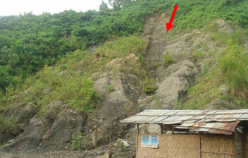
Site of Landslide in Bandarban Town (the
landslide damaged one mosque on the site in
2007)
Major part of the
municipality is developed in the land
surrounded by hills and river on the north
and east. The town is gradually been
developed on the hills without proper
consideration of its natural features. This
has resulted a number of natural disasters
like land slide in the past. After primary
field visit to the municipality it is
understood that the major structure type of
the buildings in the town is a combination
of masonry buildings, bamboo frame structure
and Reinforce concrete structure.

|
|

|
|
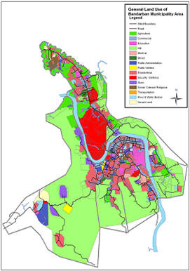
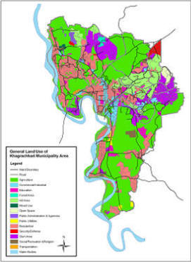
General Land use of Bandarban and
Khagrachari Municipality (UGIIP,
LGED,2007) |
Khagrachari
Khargachari pourashava is
located within the jurisdiction of
Khagrachari Sadar Upizilla of Khagrachari
District. Total area of the municipality is
13.04 sq. km. with a total household number
of 8134 (BBS Report, 2005).
Major part of the
municipality is located on plain land. Most
attractive places of the town includes
Alutila, Dharma pukur, Aronno kutir,
chengi bridge, switzerland park, dighinala
jhulonto bridge etc. Major structure type of
the buildings in the town is a combination
of masonry buildings, bamboo frame structure
and Reinforce concrete structure. The town
is comparatively low in building density and
fine grain in spatial distribution.
|


