|
|
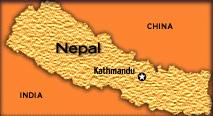
Nepal

Nepal a
mountainous country boasts seven of the world's
eight highest peaks, including the Mount
Everest. 80% of the land area of 147,181 sq. km
is made up of mountains and hills. It is also a
landlocked country with its nearest point to the
sea being 960 km away. It has a unique
altitudinal variation from 60 m at Jhapa in the
south to 8,848 m at Mt. Everest in the north,
quite a big variation in such a small
 country.
The Terai plain, a low and flat land
(100m-300m), stretches in the southern part of
the country along the Indian border. The
orogenic movement of the mountains make Nepal
most vulnerable to earthquakes. Hinduism and
Buddhism are the two main religions practiced in
Nepal. There are some 2,700 shrines in the
Katmandu Valley. country.
The Terai plain, a low and flat land
(100m-300m), stretches in the southern part of
the country along the Indian border. The
orogenic movement of the mountains make Nepal
most vulnerable to earthquakes. Hinduism and
Buddhism are the two main religions practiced in
Nepal. There are some 2,700 shrines in the
Katmandu Valley.
Nepal is exposed
to most disaster types ranging from earthquakes,
floods, landslides, droughts, storms,
avalanches, hailstorms, fires, epidemics and
ecological hazards. A wide range of
physiological, geological, ecological,
meteorological and demographic factors
contribute to the vulnerability of the country
to disasters. Major factors contributing to
disasters are rapid population growth, slow
economic development, a high degree of
environmental degradation, fragility of the land
mass and high elevation of the mountain slopes .
Earthquakes:
Nepal lies in a
region of high seismic activity. Earthquakes
with magnitudes of 5 to 8 on the Richter scale
have been experienced throughout the country and
279 earthquakes with epicenters in Nepal and
magnitudes above 3.9 have been recorded so far.
The country's high seismicity is related to the
presence of active faults between tectonic
plates along the Himalayas, mainly in the main
boundary fault and the main central thrust.
Chains of active faults run for around 100 km,
interrupted by inactive sections. There are also
active faults in the lower Himalayas and along
the southern slope of the Siwalik range. One
main reason for Nepal's vulnerability to
earthquake is the poor construction of public
buildings and house especially in densely
populated areas like Kathmandu.
Floods and Landslides:
Floods and
landslides are often interrelated in Nepal. Some
landslides are triggered by riverbank erosion,
and some flash floods are aggravated by
landslides in the areas adjoining riverbanks.
Both these phenomenon occur during the monsoon
season. Glacial lake outburst floods are common
in the Himalayan region, and are triggered by a
wide range of hydrological, geological and
seismic factors. Disastrous flash floods usually
occur in Nepal when landslides or debris block a
river for several hours and the water is then
releases suddenly, inundating the adjacent area
downstream in a rapid and turbulent manner.
Continuous heavy rainfall may also cause flash
floods in many rivers originating in hilly
regions. Flash floods may also be caused by an
avalanche, snowstorm or cloudburst.
A significant
number of landslides occur each year, roughly
estimated to over 12,000. Various natural and
man-made factors contribute to the high
incidence of landslides. Natural factors include
steep slopes, undercutting of their banks by
incised rivers, weathered, fractured and weak
rocks in the mountains, high rainfall and
seismic activities. Man-made factors responsible
for landslides in the country are intensive
deforestation, improper agriculture and
irrigation practices, overgrazing on the slopes,
quarrying for construction materials, and
construction of infrastructure beyond the
bearing capacities of the hill slopes,
Landslides frequently occur in the monsoon
season following an earthquake in the previous
year.
Fires
Most fires occur
during summer, particularly in the Terai region
when the temperatures are high and strong winds
occur. Some of the reasons for the fire
outbreaks are poor use of fire, for cooking and
other purposes and lack of adequate fire safety
measures. Forest fires are also common in the
hilly areas of Terai forests.
Nepal has had a
history of severe droughts and famines too.
Other disasters include epidemics such as
measles, cholera, encephalitis, dysentery and
diarrhoea, and storms.
Main source:
Russell,Nicholas.
Acharya, Madhu Rahman and Pant, Ram 1990. "Nepal
Country Study " in Disaster Mitigation in Asia
and the Pacific published by ADB.
|
|

