|
Cambodia

 The
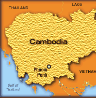
Kingdom of Cambodia or Kampuchea as it was
earlier called, is located in southeast Asia
between latitudes 13 00 N and longitudes 105 00
E. It covers an area of 181,040 sq km with
Thailand, and Laos to the north, Vietnam to its
east and the Gulf of Thailand to the south. Once
the center of the famous Khmer Empire, today
Cambodia is still recovering from the aftermath
of years of war and strife. The topography is
mostly low, flat plains, but there are three
mountainous areas in the south-west, northern
border with Thailand, and the north-east.
Roughly three-fourths of the country is covered
by tropical forest; of which only one-fifth is
arable land. The bulk of the remaining land is
composed of sandy and infertile soil. The
Kingdom of Cambodia or Kampuchea as it was
earlier called, is located in southeast Asia
between latitudes 13 00 N and longitudes 105 00
E. It covers an area of 181,040 sq km with
Thailand, and Laos to the north, Vietnam to its
east and the Gulf of Thailand to the south. Once
the center of the famous Khmer Empire, today
Cambodia is still recovering from the aftermath
of years of war and strife. The topography is
mostly low, flat plains, but there are three
mountainous areas in the south-west, northern
border with Thailand, and the north-east.
Roughly three-fourths of the country is covered
by tropical forest; of which only one-fifth is
arable land. The bulk of the remaining land is
composed of sandy and infertile soil.
The Mekong and Tonle Sap
(Great Lake) are the major water source. The
climate is governed by two monsoons: the cool,
dry northeastern monsoon from November to March
and the humid south-western monsoon from May to
October. Average annual temperatures vary from
21 to 35oC (70 to 95oF).
The major disasters faced
by Cambodia are floods, droughts, forest fires,
landslides and storms. Besides the natural
hazards Cambodia also suffers from man-made
disasters like armed conflict with its resultant
problems of refugees and displaced people, and
landmines.
Floods:
The main reasons for
floods are deforestation, erosion of the
riverbanks, causing the river to become
shallower, lack of building and engineering
codes, lack of irrigation systems and heavy
rains. The two main types are the flash floods
and river floods occurring mainly during the
rainy season.
Storms:
Cambodia was hit by
Typhoon Linda in 1997. The Pou lo wei island was
affected the most causing wreckage of 81 fishing
boats and hundred of victims.
Links:
For latest report on disasters in Cambodia
Other disasters
Landmines in Cambodia
http://www.refintl.org/demining/camaccounts.shtml
http://members.aol.com/Combodia/mines.htm
International Agencies
American Red Cross
Care
World Bank
LWS Cambodia
Email:
lwscam@bigpond.com.kh
|

