|
|
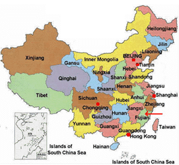
CHINA


The People's Republic of
China is home to one of the oldest civilizations
in the world, existing over 5000 years. China,
situated in East Asia between latitudes 35
degrees north and longitudes 105 degrees east
occupies a total area of 9.6 million square
kilometers; almost the entire central and
eastern Asia. It is the most populated nations
in the world. China is bound by Russia and
Mongolia to the north; North Korea in the
northeast; the former Soviet Republics of
Tajikistan, Kyrgyzstan and Kazakhstan in the
northwest; Afghanistan, Pakistan, India, Nepal
and Bhutan to the west and southwest; and
Myanmar, Lao PDR and Vietnam to the south. The
major cities of China are Beijing (capital),
Shanghai, Tianjin, Chongqing, Guangzhou, and
Shenzhen.
China has a diverse
topography ranging from highlands to the coastal
lowlands. China's relief is high in the west and
low in the east, making the rivers flow
eastwards draining into the East China Sea.
Qinghai-plateau, known as the "roof of the
world" with an average height of 16,500 feet,
one of the highest points in the world is
located here. The five major landforms found
here are the mountains, plateaus, hills, plains
and basins.
This diverse topography
consequently affects the climate of China making
it equally diverse ranging from extremely dry,
desert-like conditions in the northwest to
tropical monsoons in the southeast. Owing to
this extreme climate China suffers from a
variety of natural disasters such as
earthquakes, floods, landslides, droughts,
typhoons, forest-fires etc. Among all these
hazards, droughts, floods, earthquakes and
typhoons are the most destructive.
Floods:
Floods are one of the
most frequent hazards that affect China. Most of
the floods occur in June-July. Since 1949, China
has been struck by floods on an average of 5.8
times a year. The swelling of the four rivers,
such as the Yangtze, Yellow, Huaihe and the
Haihe rivers is one of the main causes for
flooding. The area most affected by rainstorms
and floods are the southeastern coastal regions,
the Yangtze River and the Huaihe river valleys
Landslides:
On an average over 100
landslides occur annually. One of the main
causes for landslides and cave breaks in
deforestation.
Earthquakes:
Earthquakes occur mainly
in the southwestern and the northwestern regions
of China. China has suffered more that 50
earthquakes of force 7 or greater magnitude on
the Richter's scale. According to statistics
China accounts for about 50% of the global
deaths by earthquakes. One possible cause
attributed to this high death toll is that it
affects a greater number of people, because of
the high population.
Typhoons:
China has a coastline of
more than 18,000 kms long, which is main area
that suffers the most serious and frequent
typhoon and windstorms. There are about twenty
typhoons affecting the Chinese coastal areas
every year, about seven of which land on an
average.
Droughts:
Floods and droughts
alternate every year. On average droughts are
experienced 7 times a year. The agricultural
areas of the eastern China encompassing the
Yellow River and Huaihe River, Haihe river
valleys, record a high frequency of droughts
Main Source:
National Report of the People's Republic of
China on Natural Disaster Reduction.
Links:
China Disaster Relief
|
|

