|
Lao PDR

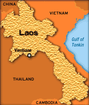
Lao PDR is a landlocked
country situated in South East Asia between
latitudes
 18
00 N and longitudes 105 00 E. Having a total
area of 236,800 sq km Laos shares its borders
with Thailand and Burma, in the North on China
and Vietnam, in the East on Vietnam and in the
South on Cambodia. Topographically most of the
country is mountainous, with elevations above
500 meters characterized by steep terrain and
narrow river valleys. Mekong and its twelve
tributaries is the main life source. Laos enjoys
a tropical climate with cold dry season from
November through February, hot dry periods form
March and April and rains from May to October.
Temperatures range from highs around 40ĄC along
the Mekong in March and April to as lows as 5oC
in the uplands in January. 18
00 N and longitudes 105 00 E. Having a total
area of 236,800 sq km Laos shares its borders
with Thailand and Burma, in the North on China
and Vietnam, in the East on Vietnam and in the
South on Cambodia. Topographically most of the
country is mountainous, with elevations above
500 meters characterized by steep terrain and
narrow river valleys. Mekong and its twelve
tributaries is the main life source. Laos enjoys
a tropical climate with cold dry season from
November through February, hot dry periods form
March and April and rains from May to October.
Temperatures range from highs around 40ĄC along
the Mekong in March and April to as lows as 5oC
in the uplands in January.
.
The major disaster that
strike Lao PDR are floods, droughts and fires.
Floods:
Floods are by far the
most damaging of all the natural calamities that
strike Lao PDR. The central and southern regions
are most affected by the frequent floods.
Droughts:
Droughts follow floods in
their severity. Droughts like floods affect the
entire country. The timing of the droughts is
more calamitous than its intensity. If the
droughts occur just before the plantation the
entire crop gets affected, thus bringing great
loss to the farmers.
Fires
Forest fires occur
occasionally and mainly during the dry seasons.
The main cause of forest fires is slash-and burn
for cultivation and to create grazing land
animals.
Urban Fires are happen
more often. This happens with the lack of basic
infrastructure and the lifestyles.
Typhoon:
As always typhoons follow
the rains.
Links:
|

