|
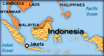
Indonesia

Indonesia formerly a
Dutch colony was known as Indos Nesos, or the
"Indian
 Islands".
It is the world's largest archipelago comprising
of seventeen thousand islands that stretch over
five thousand miles along the equator with the
total coastline exceeding 81,000 k.ms. Of these
only 6000 islands are inhabited. It lies between
latitudes 5 00 S and longitudes 12 00 E, between
the Asian and the Australian continental plates.
The five main islands are Sumatra, Java,
Kalimantan, Sulawesi, and Irian Jaya. Islands".
It is the world's largest archipelago comprising
of seventeen thousand islands that stretch over
five thousand miles along the equator with the
total coastline exceeding 81,000 k.ms. Of these
only 6000 islands are inhabited. It lies between
latitudes 5 00 S and longitudes 12 00 E, between
the Asian and the Australian continental plates.
The five main islands are Sumatra, Java,
Kalimantan, Sulawesi, and Irian Jaya.
Two
of the islands Kalimantan (known in the colonial
period as Borneo, the world's third largest
island) and New Guinea are shared with Malaysia
and Brunei, and with Papua New Guinea
respectively.
Indonesia is hot and
humid most of the year round. It has two
distinct seasons the dry season between June and
September caused by the easterly monsoons and
the wet season between December and March caused
by the westerly monsoons which brings along with
it the rains.
Vulnerability to Disasters:
Indonesia lies in one of
the most unusual areas in the world,
encompassing a major juncture of the Earth's
tectonic plates. These factors make it most
susceptibility to seismic and volcanic activity.
Another reason for the vulnerability to
disasters is that the human settlements are
situated close to hazard prone regions. The
major disaster affecting Indonesia earthquakes,
tsunami, volcanic eruptions, forest fires,
flood, and also technological failures.
Earthquakes:
Situated in the
earthquake belt Indonesia is most subjected to
earthquakes. The areas most vulnerable to
earthquakes are Sumatera, Java, Bali, Nusa
Tenggara, Maluku, Sulawesi and Irina Jaya to
seismic activity. Sumatera, alone has suffered
from over 15 earthquakes in the past 100 years
Volcanic Eruption:
Indonesia has 129 active
volcanoes, 70 are classified as dangerous, and
500 inactive ones. Between 1972 and 1991 alone,
twenty nine volcanic eruptions were recorded,
mostly in Java. In 1815 a volcano at Gunning
Tambora on the north coast of Sumbawa, Nusa
Tenggara Barat Province, claimed 92,000 lives
and created "the year without a summer" in
various parts of the world.
Floods:
The western and central
parts of Indonesia are annually inundated by
floods.
Landslides:
The islands of Java and
Sumatera are most prone to landslides because of
its unstable land
Main source:
Library of Congress
Country studies
For latest updates on disasters
in Indonesia and Country Legislation:
http://www.adrc.or.jp/nations/nationinformation.asp?NationCode=360&Lang=en
|

