- About Us
- Publications
- ADPC Academy
-
MediaADPC'S NEWS
Putting the geospatial puzzle together Putting the geospatial puzzle together
9 - 11 Mar 2017
Phnom Penh, Cambodia
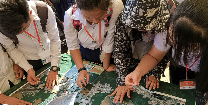
Students at the Science & Engineering Festival Exposition and Workshop (CSEF) work together to complete a satellite image puzzle of Phnom Penh, Cambodia.Each year, Cambodia’s Ministry of Education, Youth and Sport organizes the Science & Engineering Festival Exposition and Workshop (CSEF). This year’s event was held in the Phnom Penh National Stadium from March 9-11, 2017.
“We want to allow our young people to enter into the future with certainty,” said H.E. Dr. Hang Chuon Naron, Minister of Education Youth and Sport, Cambodia.CSEF engages young people to learn and get involved in areas of science, technology, engineering and mathematics (STEM). Students across the country are invited to participate and engage with teachers and practitioners to learn more about the opportunities that exist with STEM.
“This festival will give you the opportunity to embrace change, embrace technology, and the knowledge to be part of that change,” said H.E. Dr. Hang Chuon Naron.
Over 25,000 students took part in the festival, seeing how they can get involved with STEM. As part of the United States Agency for International Development (USAID) pavilion, the Asian Disaster Preparedness Center (ADPC) and SERVIR-Mekong held a booth exhibition to engage students with geospatial information systems (GIS).
Dr. Peter Cutter, Science and Data Co-Lead, SIG, describes the fundamentals of satellite imagery to students visiting the ADPC and SERVIR-Mekong booth.Funded by USAID and in partnership with the National Aeronautics and Space Administration (NASA), SERVIR-Mekong harnesses the power of space technology to address development challenges in the Lower Mekong region. ADPC, a recognized leader in strengthening disaster resilience in Asia, is the prime implementer for SERVIR-Mekong. Three other consortium partners, Spatial Informatics Group (SIG), Stockholm Environment Institute (SEI) and Deltares, assist in implementing the SERVIR-Mekong program.
Engaging young students on issues of earth observation data can be challenging. The ADPC booth aimed to simplify the concept of GIS into a practical and interactive learning opportunity. Students were asked to play the role of a satellite by putting together a puzzle of Phnom Penh. Students could see and point out landmarks and different landscapes and understand the immense potential of satellite data for development.“Participatory learning is important for young people. They want to see more images and photos, which helps drive the learning process,” said H.E. Dr. Hang Chuon Naron.
Throughout the event, students were able to learn about geospatial technology and how earth observation data provides immense opportunities for better development and environmental management. The future is bright with Cambodia’s next generation of scientists.For more information on SERVIR-Mekong please visit their website.
-